
Click to see how
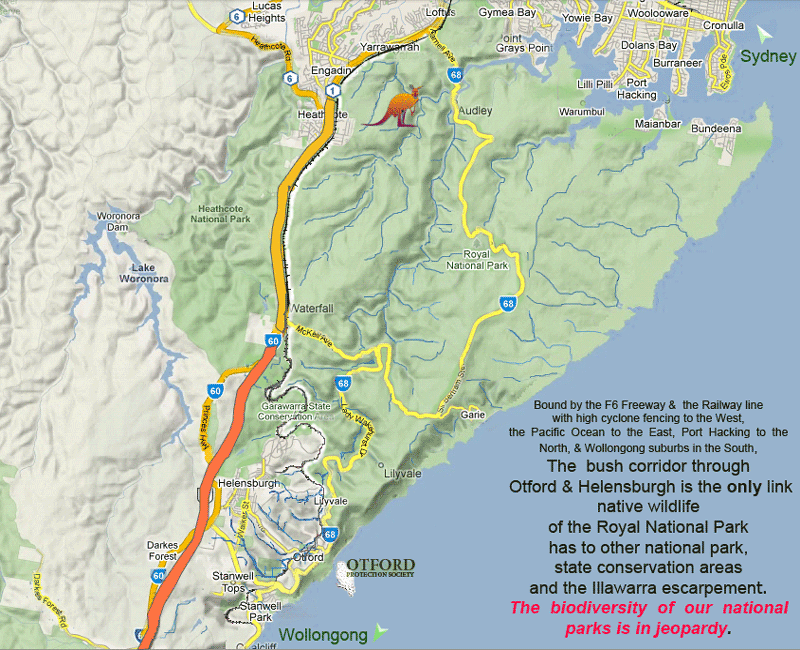
RNP's wildlife is caught between the Pacific Ocean, F6 freeway & suburbia
Bobs Bushland/Lady Carrington Estate Development
Updated: 22/2/2020
First posted: 17/1/2020
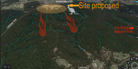 Image: The proposed site location.
Click To : HaveYourSayViaWollongongCouncil
PLEASE OBJECT TO THIS DEVELOPMENT APPLICATION
Our town and its beautiful bushland surrounds are under threat from yet more development expansion.
A consortium is behind the development. A new company has been incorporated that has two Asian principals that control well over 85% of the company. They have lodged a development application to rezone environmental classified land to R2 development, proposing 320 residential lots that may under that zoning law be re-subdivided again, possibly inflating our local population by one to two thousand more people!
There are a number of strong reasons why this development should be refused :
CURRENT ENVIRONMENT ZONING -LEP
The land between Otford Road to LilyVale Road has been
environmentally zoned for forty years, despite constant lobbying by the
respective developer owners. The current environmental zoning (changing from
environmental 7D to E3 & E2 was over a decade in the making by ratepayers,
council planners, environmental council staff, elected councillors, state
government agencies and conservationists. The finalised environmental zonings
of E2 (no new dwellings) and E3 (min 40ha for new dwelling) were decided for
good reasons, in particular due to the proximity of the (E1) Royal National
Park, State Conservation lands, and our drinking water catchment. We live in an
ecological and tourism rich area. that must be preserved. not degraded further.
SHOULD NOT BE REWARDED for Deliberately Degrading Land
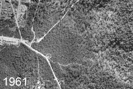
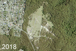
Image1: 1961 Aerial Imagery (med res) © Spatial Services (2016) Image2: 2018 Aerial Imagery © Jacobs & Aerometrex (2018)
The land proposed for development has been deliberately kept
cleared and degraded over the past twenty years. Other bushland in the 2508
region has recovered beautifully when given the opportunity, from razed to lush
temperate & dry littoral forest. It is indisputable a bushland regeneration
order dated 27th March 1980 was advised to Wollongong City Council "to
prevent further erosion of the site" by council, and has been ignored since. The owners of the proposed site should not be rewarded for the deliberate
degrading of the land. The same land was surveyed and investigated heavily in 1974 by developers on behalf of the colliery, and deemed unsuitable for development, in particular due to erosion and instability.
WILDLIFE CORRIDOR for Endangered Animals
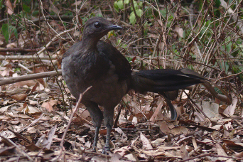
Photo: Lyrebird scratching leaves on the edge of Otford Rd. (otfordeco 11/1/2020)
“Australia is home to more than 500,000 animal and plant species, many of which are found nowhere else in the world. Over the last 200 years, more than 100 animal and plant species have become extinct. In NSW alone there are close to 1000 animal and plant species at risk of extinction.” NSW Office of Environment & Heritage
 Wildlife corridors play a critial role in fauna and flora conservation
This linkage theoretically enables migration, colonisation, interbreeding and suitable habitat for native mammals between the Royal National Park, the Illawarra Escarpment and the natural reserves/areas further south to maintain biodiversity.
The protection and conservation of the wildlife corridors is of high priority.[1]
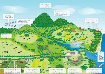
Image: Landscape elements that contribute to wildlife corridors (DEE)
- Wildlife corridors form part of a eco syterm for a variety species, some as their daily habitat range, others in times of feed migration or environmental stress
- it might provide an oppportunity for recolonisation by species that have become localy extinct
- the Lady Carrington Estate backs on to large patches of native vegtation that is core habitat for a lot of species
- and is a to endangered ecological communities
Threatened species that are commonly known or docmented in the area under the Threatened Species Conservation Act (1995) include Sooty Owls (vulnerable) and Powerful Owls (vulnerable), Barking Owls (vulnerable), Tawny Frogmouth (vulnerable), Eastern Pygmy-possum (vulnerable) and the Brown Bandicoot (vulnerable).[2][3] Other common species include Lyrebirds, Brushtail & Ringtail possums, Swamp Wallabies. EchidnaS, Feather tail & Sugar gliders and many more.
If further clearing or development occurs it willl increase physical barriersn within the corridor - roads, high fences, buildings, domestic pets, cars, traffic and pesticides.
- turning the landcape into isolated pockets of habiat
- Unkown effects to surrounding environment
- LIkely more deaths of wildlife on the internal and surrounding roads - vere levels in physical barriers
- may effect the survival of species that are under threat for other impacts
- control of domestic animals
- may disrupt the abilty for animals to find refuge in events such a bushfire
- Issuse of invasiive weeds and non-native animals
- Removal of dead wood and dead trees inlcuding the precious hollows
- Bushrock removal and disturbance.
- unkown impacts on the Hacking river catchment creeks
- the site still forms an important part of the wildlife corridor between the Royal National Park and bushland south of Helensburgh.These lands are home and a thoroughfare for

Photo: Brushtail possum in Otford - deforestation leads to them moving into roofs. (otfordeco 3/12/2019)
In the Recent bushfires have decimated other south coast wildlife populations, the Sooty Owl population has been estimated to have lost over 25%!.[4]With Lyrebirds pssabliy be add to the threatened species list[5]
RFS HAZARD REDUCTION
For the development to go ahead, the RFS stipulates that
more of the precious remaining forest surrounding the cleared site is to be
regularly cleared and burnt - therefore destroying the precious remaining tree
hollows connecting tree canopy, and understorey necessary for the nesting and
movement of arboreal wildlife. Extra housing will also increase the likely
number of roaming cats and dogs, and their horrific impact on native animals.
"A billion animals have been caught in Australia's
fires. Some may go extinct". The recent bushfire crisis provides us with a
valuable lesson in both bushfire management and conversation.
As reported in the Washington Post, wildllife corridors are
mandatory. They have been ignored at the current peril.
No greater piece of Australia, in this important wildlife
corridor to the Royal National Park, should dictate the land not be developed.
Identified Threats to Fauna Values:
High: Habitat loss due to land development; tenuous continuous habitat link between Royal NP and
the Illawarra Escarpment; weed infestation
BUSHFIRE HAZARD
The Helensburgh plateau is at higher risk of bush fire as result of exposure to greater temperatures, drying westerly winds and the sun,[1] and in particular Lady Carrington Estates, sited directly above bushland, should the Royal National Park or Garrawarra ever burn again. Two thousand more people could be added to the jammed two exit roads when 2508 are expected to evacuate in the next bushfire storm. Using the last major fire on the plateau, in the Christmas 2001 bushfires as example, the M1 was closed, Old Princes Hwy was closed, as was the Royal National Park, leaving the only escape route of Lawrence Hargrave Drive, which came to a standstill. Wollongong City Council’s Lord Mayor Bradbery was adamant that more lives should not be placed at risk in this region.
Helensburgh's population in the 2016 Census was 6,383,[6] in 2001 Census, 5,070 people.[7] Emergency services struggled Chistmas Day 2001 to evecuate the 3,000 still in town, as Helensburgh burnt around them. And the population has already increased to subdivision infill.
Videos made by the Helensburgh RFS :
Black Chrstmas 2001 Part 2 - Bushfire impacted sections of Helensburgh
Black Christmas 2001 Part 3 - Helensburgh town of 3000 attempt to evacuate
Black Christmas 2001 Part 4 - Featuring news coverage of the fire devestation
TOWN INFILL VS EXPANSION
The current LEP (Local Environment Plan) had been designed
to stop the expansion of the town's footprint, in particular from encroaching
on bushland areas. And the voted zoning allowed infill within the CBD area. There are still many existing lots within the Helensburgh town centre
that can & no doubt will be subdivided again, increasing the population
without adding a further burden of one to two thousand more people trying to
access a car space at Helensburgh railway station or the shopping district. As
locals know the railway station carpark, five km from the proposed site is full
by 7am week days. The road to the station is unfit for passing lert alone a car
and bus or even two buses.
The area does not the have the necessary infastruture to
cater for such an increase in population. The major hospitals are a minimum 30
to 40 minute drive away, and already umable to cope with the demand. Train
timetables struggle to meet the demands of the existing northern Illlawarra network,
and accidents bring commuters to a standstill with long delays, given the topography prevents alternative transportation.
EMPLOYMENT OPPORTUNITIES- DIMINISHING AS POPULATION INCREASES
The developers say that the new houses will increase
employment opportunities - however this has proved to be a fallacy! Helensburgh
and Otford are commuter towns. Many of Sydney’s highest occupancy areas from
Oxford Street to even Cronulla, have increasing number of vacant shops and factory
sites. Our employment opportunities have greatly diminished due to imports,
online shopping, manufacturing overseas and a skills shortage. If anything, the
surge in population will greatly increase competition for existing jobs in the
area - most employment opportunities exist with local cafes and specialty stores.
UPPER HACKING RIVER CATCHMENT

Photo: The Upper Hacking River - highly vulnerable to pollution run off. (otfordeco 21/1/2020)
"The escarpment contains the Illawarra Escarpment Subtropical Rainforest (S_RF01) ecological community, which has been declared an endangered ecological community, under the New South Wales TSC Act."[8]
The ecological community's northern boundary of occurrence is the Port Hacking estuary - down slope from the proposed development site. We cannot permanently defy gravity; everything that is loose or fluid on the plateau will eventually make its way downslope. The proposed site is smack at the top of the Hacking River catchment's creeks. The 2508 area is built on a sandstone, clay and shale base - all known as flashy; as water moves quickly from the surface & highly susceptible to erosion. To slow down water shed, and increase the temperate rainforest density, in itself, a natural firebreak, we should be planting more trees not building more houses or digging in stormwater channels. No matter what retention ponds or stormwater channels are placed, the proposed development will have a negative impact on the estuary, from fast water shed to garden fertilizer, effluents to erosion, to general litter.
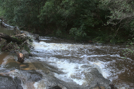
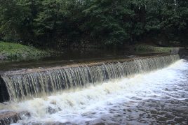
Image1: Otford causeway. (otfordeco 10/2/2020) Image2: Otford weir. (otfordeco 10/2/2020)
SPECULATIVE DEVELOPER INTEREST
It is of note that the majority of the developer consortium
do not live in the 2508 region, and will not be personally affected by the
negative impacts of the proposed development. It is not remotely an altruistic
venture, but a speculative one for profit on the rezoning of cheaply acquired
environmentally zoned land with the hope of lobbying to turn it into profitable
concrete.
STATE PLANNING
As per council's report "The rezoning is inconsistent
with the mapping shown in the Illawarra Biodiversity Strategy and the
Conservation Mapping in the Illawarra Shoalhaven Regional Plan"
Given the relative isolation of Helensburgh to south Wollongong, lack of egress and lack of instructure and conflict of high environmental values, the Helensburgh area does not form a part of the NSW state government Shoalhaven and Illawarra Regional Plans for population growth or urbanisation.
Submissions documents | ||
Lady Carrington Estates General Submission | Submission (A) Lady Carrington Estate South | Lady Carrington Estates General Submission in Bullet Points |
PLEASE HAVE YOUR SAY & tell Wollongong City Council that this development must be refused! for some or all of the points above or others you may wish to add.
By either :
Click To : HaveYourSayViaWollongongCouncil
or email council directly --
Emaill: council@wollongong.nsw.gov.au or
Mail Locked Bag 8821, Wollongong DC NSW 2500
The General Manager
Wollongong City Council
Please quote PP-2013/3 in your email or letter.
Consultation has concluded
Learn more about environment
![]()

![]()
![]()
References
1. ↑a bOffice of Environment and Heritage (2018) 'Illawarra Escarpment State Conservation Area Plan of Management' pp.34-38.Sydney
2. ↑NPWS 2002b, Bioregional Assessment Study (Part II): Fauna of the Illawarra Escarpment, Coastal Plain and Plateau: A project arising from the Commission of Inquiry into the long-term planning and management of the Illawarra Escarpment, Wollongong Local Government Area, NSW National Parks and Wildlife Service, pp.51-142.Sydney
3. ↑DECC 2002 (APPENDIX 4 Site Profiles) Rapid Fauna Habitat Assessment of the Sydney Metropolitan Catchment Management Authority Area. Department of Environment and Climate Change, pp.181-188.Hurstville
4. ↑Hall, Bianca; Hannam, Peter (2020, January 10). "Leaked report lays bare environmental devastation of Victorian fires" .theage. Retrieved January 17, 2020.
5. ↑Morton, Adam (2020, January 24). "Lyrebird may join threatened species, as scale of bird habitat lost to bushfires emerges " .theguardian. Retrieved January 25, 2020.
6. ↑Australian Bureau of Statistics (27 June 2017). "Helensburgh (State Suburb)" . 2016 Census QuickStats. Retrieved 21 January 2020
7. ↑Australian Bureau of Statistics (9 March 2006). "Helensburgh (Urban Centres and Localities)" . 2001 Census QuickStats. Retrieved 21 January 2020.
8. ↑Office of Environment and Heritage (2013) 'The Native Vegetation of the Sydney Metropolitan Area Volume 2: Vegetation Community Profiles.' pp.8-10.Sydney
RELEVANT STUDIES
Bioregional Assessment Study Part1 Native Vegetation Of the Illawarra Escarpment & Coastal Plain
Bioregional Assessment Study Part !! - Fauna of the Illawarra Escarpment Coastal Plain & Plateau
NSW GOVT Plan of Management - Illawara Escarpment State Conservation Area
Dept Environment- Threatened & Pest Animals of Greater Southern Sydney
Rapid Fauna Habitat Assessment of the Sydney Metropolitan Catchment Management Authority Area