
Click to see how
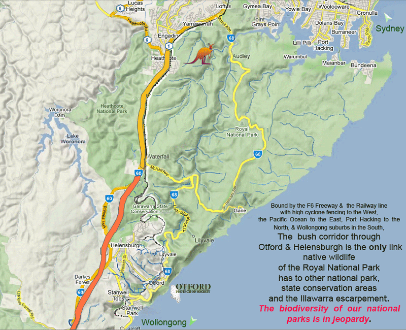
RNP's wildlife is caught between the Pacific Ocean, F6 freeway & suburbia
Lady Carrington Estates General Submission
PP-2013/3
The revised proposal proposes that:
- 17.81 hectares is rezoned to R2 Low Density Residential, with a minimum lot size of 449m2
- 1.39 hectares to E4 Environmental Living, with a minimum lot size of 1,250m2
- 1.51 hectares to RE1 Public Recreation,
- 0.89 hectares to E3 Environmental Management, and
- the balance of 184.06 hectares retaining an E2 Environmental Conservation Zone.
I object to the Proposal for the following reasons
Concerns
Planning
There is no current strategy which identifies Helensburgh for future residential release
(2019 WLPP Advice to Council –minutes)
The environmental reasons for the current zoning have not changed but have intensified
The Rezoning Proposal will cause expansion of Helensburgh outside town boundaries into environmental zones. The rezoning pushes residential subdivision into land currently zoned E2 and E3.
The proposed rezoning of E2 Lands for residential is outside the recommendations of the JRPP and is unacceptable.
It creates a precedent for urban development proposals outside the town boundaries of Helensburgh. Once the town boundaries are broken there is much less justification to prevent new ones from the same fate.
It violates the holistic approach and deliberations of Wollongong Council 7(d) review taken over 2 years from 2010 to 2011 for rezoning outside the town boundaries of Helensburgh.
The proposal would initiate the multitude of negative aspects and edge effects associated with the imposition of residential areas into lands valued for their unique environmental qualities and
The proposed rezoning would be a further illustration of bad planning by now extending urban runoff into new tributaries of the Hacking River.
Environmental
The rezoning creates a peninsular of urbanisation which imposes itself into current E3 environmental zoning
The rezoning proposal does not maintain or improve the current status of the environmental zone in which it is proposing to invade.
The rezoning will remove and destroy 12.1 ha of native vegetation
The rezoning will remove and destroy 2.7 ha Endangered Ecological Community (EEC) Southern Sydney Sheltered Forest
This rezoning introduces negative factors into an area which has been an established environmental zone for 32 years.
The rezoning will introduce negative impacts detrimental to Royal National Park –( water quality, increased weed invasion and infestation, reduced wildlife corridor, reduced urban buffer, increased wildlife road kills).
The rezoning will not maintain or improve the available free open space of non-urban or undeveloped land available for wildlife corridors of servicing the Royal National Park
The rezoning will remove some 25.5 hectares of quite open space which forms a multidimensional natural buffer to nearby residential and helps protect the Central Bushland an area of great importance to wildlife outside the Royal National Park.
Otford Creek, the tributary of Gardiners Creek and Gardiner’s creek and Gardiners Gully are currently near pristine and run in class one riparian zones in excellent native bushland. Weeds are scarce and so the headwaters should be protected if the spread of weeds throughout these catchments
Wildlife Corridor
The wildlife corridor the rezoning constricts is the most important wildlife corridor connecting the Royal National Park to outside natural bushlands.
The rezoning proposal creates an urban peninsular which reduces the width of the corridor between Helensburgh and Otford by 35% not including negative edge effects.
Edge Effects
There would be increased pressure by residents for hazard reduction burns eastward further into the Central Bushland further impacting the corridor.
Edge effects include hazard reduction burns and tree thinning, loss of understorey for small birds, increased tree damage from insect attack due to loss of small birds, dieback of trees due to insect attack, increased movements and penetration by pet dogs and cats, scent marking by dogs and cats, the noise from barking dogs, weed infestations and the spread of exotic non-indigenous plants, increased human trespass and forged tracks, mountain bike trail creation and riding, trail bike use, artificial odours, artificial light penetration at night
Vegetation
The rezoning will remove and destroy 12.1 ha of native vegetation.
The rezoning will remove and destroy 2.7 ha Endangered Ecological Community (EEC) Southern Sydney Sheltered Forest
Weed infestation
Weed invasions provides one of the greatest threats to the natural integrity and conservation value of these environmental lands
The rezoning will cause disturbance of the ground and clearing of natural bush which will increase light availability and thereby favour the invasion of weeds.
The rezoning will introduce new weeds into an existing environmental zone currently devoid of them.
The rezoning will expose the total area of 35 ha to weeds during site alteration
Roads and tracks
The presence of roads and tracks has important consequences for the spread of exotic plants.
The current plan shows a network of fire access trails crossing the outer zone. This would cause weed propagation and infestations on a continual basis.
Open Space
The rezoning would result in the loss of current open space. Even in an environmental zone areas of open space are of benefit to native species for movement and feeding of native species including the Powerful Owls and Sooty Owls classified as Vulnerable.
This area also provides a natural buffer between the residential housing at Werrong Road and Shannon Drive with the highly valued Central Bushland to the east.
Fragile Soil Exposure
The rezoning and residential development is occurring on soils well known for high erosion hazard as pointed out by the proponent’s consultants.
Increased sediments from urban runoff deposit in streams and provide ideal beds for weed growth and also transport additional nutrients into the ecosystem bound to the surface of the sediment particles and this increases the nutrient availability to plant growth.
The asset protection zones for the proposed R2 Low Density Residential and fire-trails will expose new areas for soil erosion.
Water Quality
The water quality along the Hacking especially at Otford in times of no rainfall it is atrocious.
The proposed the storm water treatment ponds planned release water still loaded with soluble nitrates and phosphates which will enhance the new growth of weeds along the three currently fresh tributaries into which it will flow.
This pollution will then add to the current poor amenity and quality of the water at Otford plus enhance further algal filaments and promote more weed growth.
Otford will be receiving pollution from Helensburgh.
Storm Water
The rezoning places residential developments and their storm water retention ponds at the top of streams where the overflow from high volume rain deluges will artificially add unnaturally large water volumes to immature streams in this case with steep slopes. Overflow will also nullify treatment of storm water adding increased pollution to catchment streams which have clean water
Stormwater pollution control facilities such as sediment ponds are beneficial but cannot and will not remove pollution in the form of dissolved nitrates and phosphates causing algal blooms and weed infestations.
Storm Water Volumes
Alterations to the hydrology of the system caused by increased peak flow and runoff coefficients alter moisture levels, will increase the potential for weed invasion.
The proponent’s consultants should be using rainfall data from Helensburgh taken over two years rather than the data they used from Sydney.
They should also state the holding capacity of the system and the likelihood of overflow.
The proposal will add weed promoting pollutants to the waters released from the site after treatment.
There will be no maintain or improve but the water quality will get worse.
Social Impacts
Bushfire
The rezoning creates a peninsular of urbanisation which is flanked on all sides by native forests.
The rezoning proposal places the residential area at the top of a hill and as flame rise it is highly likely to suffer crown fire attack especially from the south across Otford Road and to the east. It is also highly likely to suffer from ember attack from neighbouring fires given its front line location next to bushland.
The proposed residential street design provides one exit on a traffic calming roundabout in a five way junction. This is a recipe for congestion and worse in the event of the call for the rapid evacuation of some 450 residential dwellings with population conservatively estimated at 1350.
This would not be a welcome addition in the circumstances given the evacuation of the current town of Helensburgh is already severely limited by just two main exists.
Employment
There is no immediate or imminent industry or employers arriving at the town which will give employment to some 450 residents.
This will mean the rezoning will make Helensburgh a greater satellite suburb of Sydney and to a lesser extent Wollongong. This will increase the volume of commuting necessary placing further pressure on the existing road and rail system.
Transport
The rezoning creates a large separate estate at the extremity of the town far from the railway station. This is not ideal for public transport. The bus stop servicing the station is at least 150m from the closest residence. This is most discouraging in times of severe rains.
Road
The proponents consultant report ‘The Road Network Assessment by Traffic Impact Service 08-2018’ concluded the proposed subdivision will have minimal impact on the greater network of Helensburgh.
There is no consideration of the impacts extra cars accessing the railway station.
An extra 100 odd cars per day will cause congestion and grief to the residents. The parking facilities are not waiting for more. Local residents near the station and commuters will have to absorb more parking troubles and the community will suffers years of pain before it is addressed if at all.
Road access to the Rail Station very poor
A deficiency in the study is that at the Lawrence Hargrave Drive Intersection study takes no account of traffic using Temple Road to access Lawrence Hargrave Drive
Rail
The rezoning creates a significant number of commuters who will add to the current parking concerns at the railway station.
The car park at Helensburgh Railway Station has had a recent expansion and modernisation. The Neighbourhood Forum has been advised that it is commonly full by 7.20 a.m. of a morning and that commuters were parking in concerning situations because of the lack of adequate parking in the nearby narrow twisting streets.
Other advice indicates similar saturation at Waterfall railway station car park.
Some train services in the peak travel times provide few spare seats at Helensburgh of a morning.
It should be noted that Otford Rail car park has only 10 marked spaces and these are of course taken by local residents.
Retail Impacts
Parking at Helensburgh retail outlets has suffered with the release of Landcom 1, 2 and 3 developments. Space around the retail outlets is already at a premium. The addition of even 100 cars from the proposed rezoning at peak times would make the situation unacceptable and highly stressful to residents.
There appears to be no location on offer for another large car parking station like the current undercover car park at Coles.
The rezoning would create a new problem due to current facilities being at capacity and not currently ready for new releases.
Recreation and Youth outlets
The proposed rezoning creates an isolate peninsular of urbanisation at the extremity of the town.
The whole residential area would occur as a detached limb linked by single road entry with an unpopular roundabout. The design and location is very isolationist from the outset. This has implications for the wellbeing of the residents.
The amount of open space provided for the public is considered inadequate and is poorly located. In particular, there is no centrally located open space.
The proposal does not provide any direct public benefit outcomes, as the areas of open space would only be able to accommodate passive recreational activities. Alternatives should be explored so that any future subdivision will provide some greater, broader community benefits.
Clearly the rezoning is planning to maximise the number of residential spaces at the expense of consideration of basic public amenity and activities for youths.
Conclusion
The revised proposal is worthy of outright rejection due to its violation of the principles the area was zoned environmental and the multitude of unwanted negative factors it would bring to the area in total. On sustainability grounds it is desirable to limit the potential for population increase in the Helensburgh area which should be reflected in land zonings. Helensburgh residential has a disproportional impact on the surrounding highly valued environment and further increases just extend and repeat the problems at the expense of a finite and already compromised natural environment. Further residential will lead to increased penetration of exotic plants, weeds and animals into bushland area with adverse impacts for biodiversity.
The proposal illustrates the worst of planning where the cost benefits reward the few for the greater loss of the natural environment, the broader population and tourism at large.
Having reviewed the preliminary planning documentation for Lady Carrington Estate South I do NOT agree the proposal should proceed for the reasons given in my submission.
I support the current Environmental Conservation zoning for the land under consideration and further believe the current E2 and E3 land should be united as an E2 zoning and regeneration occur where necessary.
PLEASE HAVE YOUR SAY & tell Wollongong City Council that this development must be refused! for some or all of the points above or others you may wish to add.
By either :
Click To : HaveYourSayViaWollongongCouncil
or email council directly --
Emaill: council@wollongong.nsw.gov.au or
Mail Locked Bag 8821, Wollongong DC NSW 2500
The General Manager
Wollongong City Council
Please quote PP-2013/3 in your email or letter.