
Click to see how
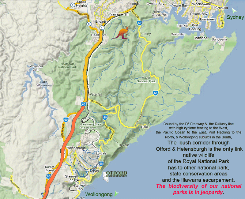
RNP's wildlife is caught between the Pacific Ocean, F6 freeway & suburbia
Submission (A) Lady Carrington Estate South
PP-2013/3
Rezoning Proposal
The revised proposal proposes that:
- 17.81 hectares is rezoned to R2 Low Density Residential, with a minimum lot size of 449m2
- 1.39 hectares to E4 Environmental Living, with a minimum lot size of 1,250m2
- 1.51 hectares to RE1 Public Recreation,
- 0.89 hectares to E3 Environmental Management, and
- the balance of 184.06 hectares retaining an E2 Environmental Conservation Zone.
I object to the Proposal for the following reasons
Concerns
Planning
There is no current strategy which identifies Helensburgh for future residential release
(2019 WLPP Advice to Council –minutes)
The environmental reasons for the current zoning have not changed but have intensified
The Rezoning Proposal will cause expansion of Helensburgh outside town boundaries into environmental zones. The rezoning pushes residential subdivision into land currently zoned E2 and E3.
The proposed rezoning of E2 Lands for residential is outside the recommendations of the JRPP and is unacceptable.
It creates a precedent for urban development proposals outside the town boundaries of Helensburgh. Once the town boundaries are broken there is much less justification to prevent new ones from the same fate.
The Rezoning Proposal initiates expansion of Helensburgh outside town boundaries in an opportunist and ad hoc manner. It is an expansion simply for the specific requests of current syndicate of ownership for their advantage.
It violates the holistic approach and deliberations of Wollongong Council 7(d) review taken over 2 years from 2010 to 2011 for rezoning outside the town boundaries of Helensburgh.
The rezoning is inconsistent with the mapping shown in the Illawarra Biodiversity Strategy and the Conservation Mapping in the Illawarra Shoalhaven Regional Plan – as stated by the Wollongong Local Planning Panel WLPP
The rezoning appears to contravene the principles laid down in the Illawarra Regional Strategy Section 7 dot point 6 and Appendix A-1 Section 7 Dot points 2, 3, 4, 5
The Study area of 39ha was zoned environmental 7(h) then 7(d) then E3 for three major considerations.
It is part of the Hacking Catchment and water quality in the Hacking River has been identified as a highly significant concern.
It is a critical section of the most viable wildlife corridor servicing the Royal National Park
It provides essential biophysical vegetation communities and open space providing refuge and feeding opportunities for the native fauna found in the surroundings.
The proposal would initiate the multitude of negative aspects and edge effects associated with the imposition of residential areas into lands valued for their unique environmental qualities and
The proposed rezoning would be a further illustration of bad planning by now extending urban runoff into new tributaries of the Hacking River.
The Proposal begins urban expansion and its edge effects into a new water catchment. Once east of the current limits of Helensburgh residential at Shannon Drive, the water runoff enters three significant tributaries of the Hacking River. They are Gardiners Creek, a significant tributary of Gardiners Creek and what the proponent’s consultants are calling Otford Creek. From Otford Creek residential runoff and pollutants released from the proposed Stormwater Treatment Ponds or directly in the case of rain deluges exceeding their capacity would now be heading for Otford and the Hacking.
Housing developments and their storm water retention ponds should be placed near areas capable of handling heavier flows much further downslope where creeks are well established and drainage channels are large
The rezoning is sited on fragile highly erodible soils and so should be avoided.
The rezoning places residential developments within environmental zones increasing markedly the possibility of accidental, negligent or deliberate disposal of certain toxic materials down stormwater drains or into the bush, creeks or dumps, including herbicides, pesticides, lime, arsenic, motor vehicle wastes.
Environmental
The rezoning creates a peninsular of urbanisation which imposes itself into current E3 environmental zoning
The rezoning proposal does not maintain or improve the current status of the environmental zone in which it is proposing to invade
The current requirements for improving disturbed lands are
- no pavements
- no hard surface streets causing increased water runoff
- no roofs causing increased water runoff
- no grassed verges or lawns with non-native grasses
- less stormwater
- increased native vegetation planting in the catchment
- no removal or destruction or damage to native trees and understorey
This rezoning introduces all these negative factors into an area which has been an established environmental zone for 32 years.
The rezoning proposal is a recipe for destruction of natural bushland by human-induced factors
The rezoning will introduce negative impacts detrimental to Royal National Park –( water quality, increased weed invasion and infestation, reduced wildlife corridor, reduced urban buffer, increased wildlife road kills)
The rezoning will not maintain or improve the water quality of the Hacking River The three proposed storm water Retention Ponds do not release pure water but water high in nitrates and are also prone to failure and releasing higher polluted water during deluges
The rezoning will not maintain or improve the available free open space of non-urban or undeveloped land available for wildlife corridors of servicing the Royal National Park
The rezoning will remove some 25.5 hectares of quite open space which forms a multidimensional natural buffer to nearby residential and helps protect the Central Bushland which was supported by a majority of 7(d) review submissions and Council for an E2 zone and has stands of endangered Sydney Southern Sheltered Forest EEC.
The rezoning will remove and destroy 12.1 ha of native vegetation
The rezoning will remove and destroy 2.7 ha Endangered Ecological Community (EEC) Southern Sydney Sheltered Forest
Increased road kills due to increased tourism and visitations to the Royal National Park (now 6 million visitations annually) and the broader area of Bald Hill, Stanwell Park Otford area is causing increased pressure on the wildlife corridors. This has to be balanced by available non developed open space throughout the corridor. The rezoning will subtract 39 ha and 25.2 ha of it being residential of such density as to be a complete loss to native fauna.
The loss of 39 ha and 25.2 ha to human habitation will reduce available hunting space for predators such as the Powerful owl and Sooty Owl (both endangered) and will remove valuable open space available for the wildlife corridor for fauna as divers s swamp wallabies, echidna, lace monitors and diamond pythons.
The Proposal begins urban expansion and its edge effects into a new water catchment. Once east of the current limits of Helensburgh residential at Shannon Drive water run of enters three significant tributaries of the Hacking River. They are Gardiners Creek, a significant tributary of Gardiners Creek and what the proponent’s consultants are calling Otford Creek. From Otford Creek residential runoff and pollutants released from the proposed Stormwater Treatment Ponds or directly in the case of rain deluges exceeding their capacity would now be heading for Otford and the Hacking.
Otford Creek, the tributary of Gardiners Creek and Gardiner’s creek and Gardiners Gully are currently near pristine and run in class one riparian zones in excellent native bushland. Weeds are scarce and so the headwaters should be protected if the spread of weeds throughout these catchments
Wildlife Corridor
The rezoning creates a peninsular of urbanisation which imposes itself into current E3 environmental zoning
Any reduction of the size of the corridor is permanent
The rezoning does not maintain or improve the wildlife corridor. It weakens it.
There are four major wildlife corridors servicing the Royal National Park. See Appendix 1
The most significant functioning wildlife corridor is the referred to as the ‘wet’ or ‘moist’ or the Rainforest / Tall open forest wildlife corridor east of Helensburgh and west of the Illawarra rail line.
The Royal National Park performs a significant role in conservation providing essential habitat for native animals. Wildlife corridors provide for a continual interchange of populations and perform a vital role in times of stress from factors such as drought and bushfires
It is vital significance is well established as it primarily services the rain forest and tall wet forest which are highly significant features of Royal National Park. The viability of the wet corridor is essential for the health and genetic diversity of the native fauna within the Royal National Park.
The wildlife corridor the rezoning constricts is the most important wildlife corridor connecting the Royal National Park to outside natural bushlands.
This corridor is already highly compromised by current human imposed infrastructure, transport corridors, residential development, past logging, the removal of hollows and pest species such as deer.
The removal of hollows has a direct influence on the population size for many dependent species and also results in increased vulnerability to fire.
The rezoning removes the flattest section of the wildlife corridor between Helensburgh and Otford. This will have a negative effect on the corridor since this is the area providing the most convenient and easiest section to traverse for creatures like swamp wallabies. Like humans they prefer to travel over flatter and gentle terrain which is found on ridges and not actors steeply sloping terrain.
Significantly the peninsular created by the rezoning would reduce the width of the corridor at a key location by 35% not allowing for edge effects.
Edge Effects
There would be increased pressure by residents for hazard reduction burns eastward further into the Central Bushland further impacting the corridor.
Edge effects include hazard reduction burns and tree thinning, loss of understorey for small birds, increased tree damage from insect attack due to loss of small birds, dieback of trees due to insect attack, increased movements and penetration by pet dogs and cats, scent marking by dogs and cats, the noise from barking dogs, weed infestations and the spread of exotic non-indigenous plants, increased human trespass and forged tracks, mountain bike trail creation and riding, trail bike use, artificial odours, artificial light penetration at night
Exotic pest penetration
No information provided for prevention of native bush penetration by introduced pet species including cats and dogs.
Similarly an educational campaign aimed at informing the new residents of the importance of this section of bushland for native wildlife and a restriction on the keeping of non-native pets including cats and dogs is not proposed. Therefore the do nothing approach is being assumed by the proponents. This can only further impact and not maintain or improve the health of the wildlife corridor.
This rezoning will introduce a new but somewhat isolated residential area at the extremities of the township linked only by one road entrance. It is highly probable that rogue mountain bike activities will propagate into the Central Bushland due to its proximity as an immediate site for outdoor activity. This poses the problem of policing the area to maintain its undisturbed non fragmented natural wilderness necessary for the habitat of small mammals and small birds.
Vegetation
The rezoning will remove and destroy 12.1 ha of native vegetation.
The rezoning will remove and destroy 2.7 ha Endangered Ecological Community (EEC) Southern Sydney Sheltered Forest
The endangered Sydney Southern Sheltered Forest EEC is endangered because so much of it has been removed for residential development. The rezoning continues this threatening process with more of it.
As expressed by the Wollongong Local Planning Panel 2019 minutes
“The adjacent bushland regeneration areas are not part of the planning proposal. Therefore, concern is raised about the future mechanisms available to ensure that the regeneration occurs. “
The rezoning therefore provides no certainty or legal requirement for any maintain or improve the environmental zone into which it invades.
Also from the WLPP 2019 minutes
The interface between proposed residential development and bushland may be insufficient to prevent adverse impacts.
A concern raised in the 2016b Agency Referrals by the OEH submission page 1 paragraph 2 in reference to the Southern Joint Regional Planning Panel JRPP 2014 was that
The JRPP made very specific recommendations for the assessment of a planning proposal at this site.
The JRPP determined that the existing ‘cleared land and intervening land may be suitable for development’ as it pertained to the Lady Carrington Estate South Precinct that was mapped in Annexure A of their report dated March –July 2014. There was no urban potential recognised for the adjacent Central Bushland precinct. WE highlight our key concern that the proposed rezoning area delineated in the Rezoning Base Plan, seeks to rezone an area that far exceeds the area referenced for investigations by the JRPP and generally continues to reflect the pre-gateway footprint that was not supported by the JRPP
“the JRRP considers that only the cleared and intervening land located between the existing settlement and the cleared land be suitable for development and that the rest should be zoned E2 Environmental Conservation.
Refer to OEH response 29-06-2016 bottom of page 1
A further concern for the vegetation from the Wollongong Local Planning Panel 2019 minutes was that
The proposal for 1,000m2 lots in the north-western triangular bushland area is likely to result in the removal of most if not all existing trees and potential EEC’s which will require offsets. The proposed offsets created outside the rezoned area within existing bushland is not considered a suitable alternative.
Weed infestation
Weed invasions provides one of the greatest threats to the natural integrity and conservation value of these environmental lands
In many circumstances weeds out compete and reduce the population size or eliminate some native species entirely by way competition for water, nutrients, light and space.
Weeds have many unwanted side effects including
Being hosts of diseases and parasites of native plants or alter the habitat to favour these diseases and parasites.
Excreting substances into the soil, which have an inhibitory effect on native vegetation. For example, lantana affects many ferns adversely and may seriously deplete that component from the vegetation.
Being poisonous or causing deleterious reactions to animals thus contributing to the stress on animal populations, e.g. allergic reactions, dermatitis, sores, etc
The rezoning will cause disturbance of the ground and clearing of natural bush which will increase light availability and thereby favour the invasion of weeds.
The rezoning will introduce new weeds into an existing environmental zone currently devoid of them.
The rezoning will expose the total area of 35 ha to weeds during site alteration
Within this the 25.5 hectares of land slated for residential will be exposed during earth works and construction to new weeds. At least 45% of this total will be lost to housing by some 55% remaining will take the form of weeds as introduced grasses and some of the more obnoxious environmental weeds which are highly invasive like Verbena bonariensis (purple top), Sida rhombifolia (Paddy’s Lucerne), Lantana camara (Lantana), Ageratina adnephora (Crofton weed) and Tradescantia fluminensis (Wandering Jew) will take hold and become new permanent fixtures propagating into the future as the opportunity arises
It must be pointed out that weed infestation in Camp Gully Creek, which was originally vegetated by rainforest and now drains the major part of the Helensburgh township and is the worst weed infested creek in the Hacking Catchment, so planning new urban zones in recognised environmental zones is a recipe for land degradation by weed infestation over far greater areas than the proposed development.
The rezoning will
- introduce weeds into an area with little resistance or tolerance to weeds if disturbed;
- cause further disturbance in the catchment which is likely to increase the potential for weed invasion,
- introduce of many exotic propagules into the surrounding bushland. Some through escapes from the Stormwater retention and many through transportation of cuttings and seeds by birds
Minimising impacts by way of Stormwater retention ponds does not maintain or improve the current situation
There is no legislation in place to dictate the residents may only plant the surrounding native plants giving rise to many exotic propagules from introduced garden plants.
Concerning the Proposed adjoining bushland regeneration of 11ha
No parameters for regeneration
No schedule provided for council inspection council
No penalties described for lack of compliance
The necessary asset protection zones will be ripe for weed invasion. If left unattended weeds such as Rubus anglocandicans (blackberry) will soon propagate.
An educational campaign aimed at informing the local people of the importance of this section of bushland and at changing their attitudes to it from their regard of it as a wasteland suitable for dumping rubbish, to a valuable wildlife is not mentioned or proposed. Therefore the ‘Ignore’ and ‘do nothing’ approach is being adopted by the proponents.
The propagation of unauthorised mountain bike trails from the residential component of the rezoning will spread weed infestation by seed dispersal from the bike tyres and it will quickly be covered in fresh dirt from the bike movements and skid ensuring rapid propagation after rain.
Roads and tracks
The presence of roads and tracks has important consequences for the spread of exotic plants. They provide routes for the bearers of plant propagules (people, vehicles, horses, wind and water) and by furnishing along their margins, a highly specialised habitat for plant establishment, roads and tracks may facilitate the entry of weeds into a new area. In this manner, roads supply a cohesive directional component cutting across physical barriers linking suitable habitat to suitable habitat.
The 2019b Future Residential Development Concept Plan shows a network of fire access trails crossing the outer zone. This would cause weed propagation and infestations on a continual basis.
Open Space
The open space is currently zoned E3 environmental. The proposed rezoning eradicates this area.
The proposed rezoning would cause loss of the current gentle sloping open space available for native animal grazing and transport.
The loss of 35 ha and 25.2 ha to residential will reduce available hunting space for predators such as the Powerful owl and Sooty Owl (both vulnerable status) and will remove valuable open space available for the wildlife corridor for fauna as diverse as swamp wallabies, echidna, lace monitors and diamond pythons.
This area also provides a natural buffer between the residential housing at Werrong Road and Shannon Drive with the highly valued Central Bushland to the east. .
Fragile Soil Exposure
Increased sediments from urban runoff deposit in streams and provide ideal beds for weed growth.
Sediments also transport additional nutrients into the ecosystem bound to the surface of the sediment particles and this increases the nutrient availability to plant growth.
Increased sediments also alter the hydrology of a river by disrupting stream flow and choking channels. This results in raised flood levels, increased turbulence and increased scouring thus providing ideal conditions for further weed growth.
The rezoning and residential development is occurring on soils well known for high erosion hazard as pointed out by the Perren’s Hacking Water Quality Assessment 12-2016 page 6 and 7 and the Herman Storm Water Storm Water Quality Assessment 04-2016 page 3. Both reports relate how the Bundeena soil landscape unit is subject to a high erosion hazard and the Hawkesbury soil landscape unit has intervening layers of shallow coarse sand and sandy clay loam and is subject to severe sheet erosion where vegetation cover has been removed.
Vegetation cover removal is exactly what will occur over the asset protection zones comprising an undisclosed area of unknown hectares.
Future natural bush may be used to cover these area but in the event of fire they and any matting will be scorched and the fragile soils exposed.
The asset protection zones for the proposed R2 Low Density Residential and fire-trails will expose new areas for soil erosion.
Water Quality
The Hawkesbury Sandstone soils are generally sandy, often skeletal, well drained (unless the drainage is blocked by various physical factors) and very deficient in various elements, which are essential plant nutrients. Phosphorus and nitrogen are most important in this respect and their availability is a severely limiting factor on plant growth in the area.
The water quality along the Hacking especially at Otford and continuing to the confluence with Gardners creek is quite concerning.at times of no rainfall it is atrocious. Algal blooms and algal filaments cover the river bottom in places of occasional slow transport such as above the weirs. Weeds line the banks and the water surface looks greasy in times of low rainfall.
The Perren’s Hacking Water Quality Assessment 12-2016 and the subsequent Advisian Water Quality Assessment of 05-2018 bear this out in table after table. The most significant factor causing weed infestation and algal blooms is enrichment from soluble nitrates and phosphates. For every table dating from 1986 to 2015 the water quality has unacceptable levels of phosphorous and nitrates.
Being soluble they are exceptionally difficult and expensive to filter out.
Table 5 SPCC 1986 7 weekly samples show total exceeding default trigger values all along the Hacking at Otford.
Table 17 and the final table 29 2015 6 sampling events shows levels of phosphates and nitrates at site 5 Otford Weir down stream of Otford Creek, Site 7 Hacking River down-stream of Gardiners Creek and at the Site 12 Hacking Rover at the Joan Holland bridge all with means and the important 80th percentile values far in excess of the ANZECC trigger values for adverse biological effects. For example at Site 5 the NOx 80th percentile nitrate readings are 6.8 or an order of magnitude above ANZECC triggers.
Given the Hacking River is supposedly a class P (pristine) river the water quality at Otford down stream of just half of the storm water retention ponds planned is already unacceptable.
The Advisian Water Quality Assessment of 05-2018 notes in table 3 page 12 that the current performance targets for storm water quality for Wollongong are 60% total phosphorous removal – 40% gets through and Total Nitrogen 45% - 55% gets allowed through.
Clearly any additional dissolved nitrates and or phosphates will make the water quality in the Hacking River even worse than its current unacceptable levels.
The inherent problem facing the Hacking Catchment is the fact that the most critical upper portions as far as water quality is concerned lie outside the Royal National Park and the Garawarra State Recreation Area and are in public ownership. Public ownership includes urban sprawl at Helensburgh, the road system, rural and agricultural land, light industrial land and business enterprises. This provide broad scale pollution over roads, horse paddocks and agricultural runoff as well as point sources including a concrete batching plant, a zoo, ground fertilisers from a golf range, an olive farm, a bus depot, a plant nursery, industrial storage sites and horse stables.
The immediate problem with this new green field development as far as water quality is concerned is that Lady Carrington South Estate development further repeats the same problem. It introduces it a new source of pollution the top of hitherto unpolluted key water tributaries of the Hacking River. In this case the water sources are three Class 1 riparian zones and their associated highly significant tributaries of the Hacking River. They are ‘Gardiners Creek’, the ‘unnamed tributary of Gardiners Creek’ and the ‘Otford Road Unnamed Tributary of the Hacking River’.
The proposed rezoning will not maintain or improve the water quality in the three neighbouring down slope creeks and it will not improve the water quality at Otford.
Storm Water
The rezoning places residential developments and their storm water retention ponds at the top of streams where the overflow from high volume rain deluges will artificially add unnaturally large water volumes to immature streams in this case with steep slopes. Overflow will also nullify treatment of storm water adding increased pollution to catchment streams which have clean water
Stormwater pollution control facilities such as sediment ponds are beneficial but cannot and will not remove pollution in the form of dissolved nitrates and phosphates causing algal blooms and weed infestations.
The Herman’s Storm Water Quality Assessment 04-2016 Figure 3.2 Storm Water management plan page 7 shows a detailed mapping of a series of catchments within the subdivision and a detail of the storm water management system. It shows the overall area being divided into four sub-catchments which are not clearly separated.
These effectively combine to send the water from Catchment 1 and 2 into first of all a Humeceptor Hydrodynamic separator and then into basin 1A and 1B.
Some of Catchment 2 and the other Catchments 3 and 4 also enter Humeceptor Hydrodynamic separators and then enter 2A, 2b and 2C and 3A and what should be 3B and 3C but confusingly or mistakenly recorded as a separate 2B and 2C again.
No further details are provided to match the 2019b Future Residential Development Concept Plan dated 27-09-2019. Given three stormwater treatment ponds are shown the public has to guess they are the same. This is not acceptable.
The Herman’s Storm Water Quality Assessment 04-2016 page 10 champions the Humeceptor Hydrodynamic separators published performance data. It shows that at best the average removal efficiency of the receptors is 53% total phosphate and 37% total nitrate.
No tests are provided. Just the advertised figures are accepted. Not good enough.
Two more highly significant pieces of information are not provided.
The volume of water the Humeceptor Hydrodynamic separators can accept before overflow occurs.
The time period required for proper digestion and filtration of pollutant and nutrient loads for a full volume of water to properly exit the separator.
The water then goes into stormwater treatment ponds for which no outflow data is available.
This is unacceptable.
Storm Water Volumes
Alterations to the hydrology of the system caused by increased peak flow and runoff coefficients alter moisture levels, will increase the potential for weed invasion.
Alarmingly the Bureau of Meteorology values for Sydney were used to predict water shed.
As pointed out by the EPA Agency Response 02-08-2016 there are a multitude of faults with this report and significantly on
Insufficient data was used, page 2
The climate data was not suitable, page 4
Despite the glaring problems no new study has been achieved in 3 years.
The Perrens Hacking Water Quality Assessment 11-2016 starting page 5 A Water Monitoring Program of 2015 was carried out for 6 months. The EPA Agency Referral of 02-08-2016 noted that the ANZECC Guidelines for trigger values require two years of monthly sampling to indicate ecosystem variability which was not noted in the 2016 report.
The Advisian Water Quality Response of 14-05-2018 page 15 to the EPA Agency Response of 02-08-2016 acknowledges that 24 months of sampling did not occur but then goes on to argue that it is not required and that other data all monitored site provides the required 24 sampling events.
Wollongong Council have not pursued and EPA response to this since May 2018.
It appears the Proponents Consultant Response to EPA Criticism can set new standards for what is acceptable with ANZECC guidelines. This is not acceptable.
The Advisian Water Quality Response of 14-05-2018 page 14 to the EPA letter gives an in house support for the figures used for rainfall data based on Sydney readings and states no changes to reduction percentages. Using even the best figures there is still a 37% release of phosphorous and a 44% release of nitrogen
Again unacceptable and no maintain or improve the water quality at the top of the catchments for the three creeks.
Considering the watershed again the two key questions arise:
What is the volume of water the Humeceptor Hydrodynamic separators can accept before overflow occurs?
What is the time period required for a full volume of water to properly exit the separator having had the stated pollutant and nutrient load removed?
The Advisian Water Quality Response to the EPA letter of 14-05-2018 page 15 also advises average effective impermeable area of worst case 60% of all areas was used.
Simple calculations seem to show that with an inch of rain the two catchments shown the basin areas would be over run. The calculations are compounded by the lack of clarity as to where the sub catchments begin and end or what volumes the water of water from parts of Catchment 2 go where?
Assuming the catchment data from the Perren’s Hacking Water Quality Assessment 12-2016 is correct and which could require modification with the new 2019b Future Residential Development Concept Plan
Catchment 1 Area
(ha)
1 9.27
2 2.19
Total 11.46
Using the 2018 Advisian Water Quality Response to EPA Comments 14-05-2018 page 15 advice to run the model with a conservative EIA ( Average effective impermeable area of 60% ) for a rough calculation and 1 inch or 0.0254m of rainfall
Volume of water = depth x area
= 0.0254 m x 11.46 ha x 0.6
= 0.0254 x 1.146 x 105 x 0.6
= 1746.504 m3
This volume of water would enter the Humeceptor Hydrodynamic separator and then Basin 1A volume 40m3 and then on to Basin B capacity 140 m3. Sadly in the report the volumes are quoted in square metres and not cubic metres.
For catchment 3 with an area of 7.49ha the stormwater released for an inch of rain would be a volume of 1141.476m3 alone. Basin 2 has capacities of 2A 50m3, 2B 120m3 and 2C 140m3. Similar figures apply to Basin 3.
The Helensburgh area was deluged with rain an order of magnitude greater than 1 inch in the recent Christmas rains. An inch of rain falling in an hour is not unreasonable so will the storm water retention ponds be able to cope.
Additionally Climate Change predictions warn of increasingly large deluges as global oceans warm and greater volumes of water are carried by the cloud system.
The 2018 Advisian Water Quality Response to EPA Comments 14-05-2018 page 14 concentrates on yearly rainfall events in response to the EPA. More detail is required on the water volumes expected at the inflow of the Stormwater Treatment Ponds over shorter time periods, their immediate holding capacity, their required time to operate efficiently preforming filtration and measurement of the water quality exiting the system.
Increased Watershed impacts on Hacking River
Using the principle of an average effective impermeable area of 50% and a residential area in total of 17.81 hectares for 1 inch of rainfall the water volume unable to be absorbed is
Volume of water = depth x area
= 0.0254 m x 17.81 ha x 0.5
= 0.0254 x 1.781 x 105 x 0.5
= 4.523.77 x 103 x 0.5 m3
= 2.261.87 m3
For an average effective impermeable area of 60% it increases to 2714.24 m3.
In the scenario where the Stormwater Treatment Ponds are at capacity this water shed will be added to the Hacking River once it has further spread its erosion over the three tributaries fed by the ponds.
This could increase with deluges of 4 or 5 inches by that factor again. With Climate Change the effect will be gradually magnified. Clearly the addition of this volume of water into the Hacking River will have the secondary effect of greater flooding and increased bank erosion downstream in times of heavy rain events. This would not occur to anywhere near this extent if the current environmental zoning was preserved and the land preserved as part of the natural environment.
At present the water quality will not be maintained or improved by the proposed rezoning and so using the precautionary principle it should be discarded.
The way forward would be to avoid placing housing developments and their storm water retention ponds at the top of streams where the overflow from high volume rain deluges will artificially add unnaturally large water volumes to immature streams in this case with steep slopes
Housing developments and their storm water retention ponds should be placed near areas capable of handling heavier flows much further downslope where creeks are well established and drainage channels are large
Social Impacts
Bushfire
The rezoning creates a peninsular of urbanisation which is flanked on all sides by native forests.
The rezoning lies at the top of a hill approximately 285m AHD surrounded by native vegetation which is in time of drought and summer conditions, highly combustible.
The decision to save a fraction of bushland north of Lilyvale Road adds to the peninsular projection of the proposal into the current environmental zone.
Being at the top of a hill and given fires go upwards this proposed development is in the worst situation. It is highly likely to suffer crown fire attack especially from the south across Otford Road and to the east. It is also highly likely to suffer from ember attack from neighbouring fires given its front line location next to bushland.
The projecting peninsular design of this development into native bushland further enhances its exposed status on all fronts except the western section where it adjoins the lots along Werrong Road and Shannon Drive from Otford Road to Koornong Road.
It therefore has exposed flanks along its southern boundary with Otford Road, along its eastern boundary with the Central Bushland to the two Storm Water Treatment Ponds near the bushland of Gardners Creek, along it northern border to Koornong Road.
The best case of protection as declared by the area commander at a recent Neighbourhood forum was in the event of an approaching major bush fire to evacuate the whole town. Such a scenario occurred with the Christmas Day 2001 fire.
The immediate assembly point for all is on the Rex Jackson oval but in the event of engulfing smoke, ember attack and possible nearby blazes this is not ideal for small children, elderly and asthmatic residents. Hence the need to evacuate the town. The commander’s goal was to get resident onto the highway and moved away from there.
The road system of Helensburgh leading to the highway is by way of the two major exits from the town. Parkes Street and Walker Street. If the fire has reached the old Princess Highway then further convergence would occur at the roundabout near Symbio.
The local chief was has also expressed the opinion that there is enough problems evacuating Helensburgh as it is without another residential development of 300 lots. If bungalows are built there would be an average of 3 people per lot or 900 residents. Potentially each lot could go to dual occupancy so with an average of 6 people per lot the extra population to be evacuated would be 1800.
Of great concern is the latest road system proposed for the rezoning in the 2019b Future Residential Development Concept Plan dated 27-09-2019. The road system for the rezoning converges all traffic to a new 5 way junction at the corner of Otford Road and Werrong Road by use of a traffic calming roundabout.
This is a recipe in an emergency for a large traffic jam for residents from Otford Road, Werrong Road and now the new rezoning. There is also concern for traffic congestion and large traffic jams at the junction of Tabratong and Walker Street and Cemetery Road and Parkes Street in the event of such an emergency.
The Road Network Assessment by Traffic Impact Service 08-2018 assumed 450 dwellings with 50% dual occupancy. At just 1 vehicle per lot that equates to an extra 450 vehicles to evacuate over in over an hour. The study itself for normal operation suggests a worst case of 380 vehicles per hour.
Again this is a recipe for unacceptable congestion in the event of emergency service wanting complete evacuation of the town. The 2001 Christmas day fire took 2 hours to reach Helensburgh from Appin.
Employment
There is no immediate or imminent industry or employers arriving at the town which will give employment to some 450 residents.
This will mean the rezoning will enforce further Helensburgh becoming a satellite suburb of Sydney and to a lesser extent Wollongong. This will increase the volume of commuting necessary placing further pressure on the existing road and rail system.
Concern over this situation echoes the dissenting view expressed by Councillor George Takacs a member of the Southern Joint Regional Planning panel 30-07-2014
“on sustainability grounds it is desirable to limit the potential for population increase in the Helensburgh area and this should be reflected in land zonings. Helensburgh is placed midway between the urban agglomeration of Sydney and Wollongong. Additional residents in Helensburgh will by necessity have a large commuting foot print for work, education and medical care. Rezonings which allow for residential development on the urban fringes of Helensburgh will lead to increased penetration of exotic plants and animals into bushland area with adverse impacts for biodiversity. Population increase in the Helensburgh area should be limited to that which can occur through redevelopment of brown field sites. “
Page 17 Paragraph 3 SRPP Pre Gateway Review and Planning Proposal Review
Transport
The rezoning creates a large separate estate at the extremity of the town far from the railway station. This is not ideal for public transport. The bus stop servicing the station is at least 150m from the closest residence. This is most discouraging in times of severe rains.
Road
The proponents consultant report ‘The Road Network Assessment by Traffic Impact Service 08-2018’ concluded the proposed subdivision will have minimal impact on the greater network of Helensburgh.
To reach this conclusion in section 4.2 it used the 2016 ABS figures for Helensburgh for determining the extent of car usage. This produced a figure of 16% for train travel from the population. These figures do not reflect the increases in use of Train travel to reach work achieved since then.
The report details only four routes likely to be undertaken by occupants on page 14 being Access to the Freeway, Town centre Route, Otford South Route and Access to Stanwell Park.
Not enough detail is provided of the increased volume of cars transporting occupants to the Railway station is provided. An extra 100 odd cars per day will cause congestion and grief to the residents. The parking facilities are not waiting for more. Local residents near the station and commuters will have to absorb more parking troubles and the community will suffer years of pain before it is addressed if at all.
Road access to the Rail Station is most commonly via Parkes Street which has two horrid corners to negotiate and then into old Station Road which also features a similar curve at its southern end. Going to the station from the town centre past the intersection of Junction Street the roads are narrow and feature sharp curves. This is one issue which State and local authorities are unwilling and unable to address.
A deficiency in the study is that at the Lawrence Hargrave Drive Intersection study takes no account of traffic using Temple Road to access Lawrence Hargrave Drive
Rail
The rezoning adds further commuter cars to the satellite suburb nature of Helensburgh regarding employment, shopping and entertainment. It will create a significant number of commuters who will add to the current parking concerns at the railway station.
The car park at Helensburgh Railway Station has had a recent expansion and modernisation. The Neighbourhood Forum has been advised that it it commonly full by 7.20 a.m. of a morning and that commuters were parking in concerning situations because of the lack of adequate parking in the nearby narrow twisting streets.
It should be noted that Otford Rail car park has only 10 marked spaces.
Retail Impacts
Parking at Helensburgh retail outlets has suffered with the release of Landcom 1, 2 and 3 developments. Space around the retail outlets is already at a premium. The addition of even 100 cars from the proposed rezoning at peak times would make the situation unacceptable and highly stressful to residents.
There appears to be no location on offer for another large car parking station like the current undercover car park at Coles.
The rezoning would create a problem which has to be solved after
Recreation and Youth outlets
The proposed rezoning creates an isolate peninsular of urbanisation at the extremity of the town.
The whole residential area would occur as a detached limb linked by single road entry with an unpopular roundabout. The design and location is very isolationist from the outset. This has implications for the wellbeing of the residents.
Key concerns raised by Wollongong Local Planning Panel 2019 minutes page 2
The amount of open space provided for the public is considered inadequate and is poorly located. In particular, there is no centrally located open space.
The proposal does not provide any direct public benefit outcomes, as the areas of open space would only be able to accommodate passive recreational activities. Alternatives should be explored so that any future subdivision will provide some greater, broader community benefits.
Clearly the rezoning is planning to maximise the number of residential spaces at the expense of consideration of basic public amenity and activities for youths.
Conclusion
The revised proposal is worthy of outright rejection due to its violation of the principles the area was zoned environmental and the multitude of unwanted negative factors it would bring to the area in total. On sustainability grounds it is desirable to limit the potential for population increase in the Helensburgh area which should be reflected in land zonings. Helensburgh residential has a disproportional impact on the surrounding highly valued environment and further increases just extend and repeat the problems at the expense of a finite and already compromised natural environment. Further residential will lead to increased penetration of exotic plants, weeds and animals into bushland area with adverse impacts for biodiversity.
The proposal illustrates the worst of planning where the cost benefits reward the few for the greater loss of the natural environment, the broader population and tourism at large.
Having reviewed the preliminary planning documentation for Lady Carrington Estate South I do NOT agree the proposal should proceed for the reasons given in my submission.
I support the current Environmental Conservation zoning for the land under consideration and further believe the current E2 and E3 land should be united as an E2 zoning and regeneration occur where necessary.
PLEASE HAVE YOUR SAY & tell Wollongong City Council that this development must be refused! for some or all of the points above or others you may wish to add.
By either :
Click To : HaveYourSayViaWollongongCouncil
or email council directly --
Emaill: council@wollongong.nsw.gov.au or
Mail Locked Bag 8821, Wollongong DC NSW 2500
The General Manager
Wollongong City Council
Please quote PP-2013/3 in your email or letter.